HL-NTWC Research and Infrastructure

Infrastructures
Seismograph System
The core network that supports the HL-NTWC is the Hellenic Unified Seismic Network (HUSN). NOA-IG coordinates HUSN which incorporates more than 150 seismic stations contributed by the NOA-IG’s nationwide Hellenic Seismic Network (HL) and other local seismic networks operated by university laboratories (http//bbnet.gein.noa.gr/HL/). In addition, seismic stations located in Greece and in neighbouring countries, that belong to affiliated collaborative partner networks, such as GEOFON (GE), MEDNET (MN), INGV (IV), KOERI (KO) and Cyprus (CQ), are also included in the near real-time acquisition and storage as it is performed at NOA-IG’s HL. The recorded data by HL are sent to the National Data Centre (NDC) via the SeedLink protocol where they are processed automatically (SeisComp3 analysis suite) and analysed manually by operators in a 24/7 mode (Nanometrics processing suite).
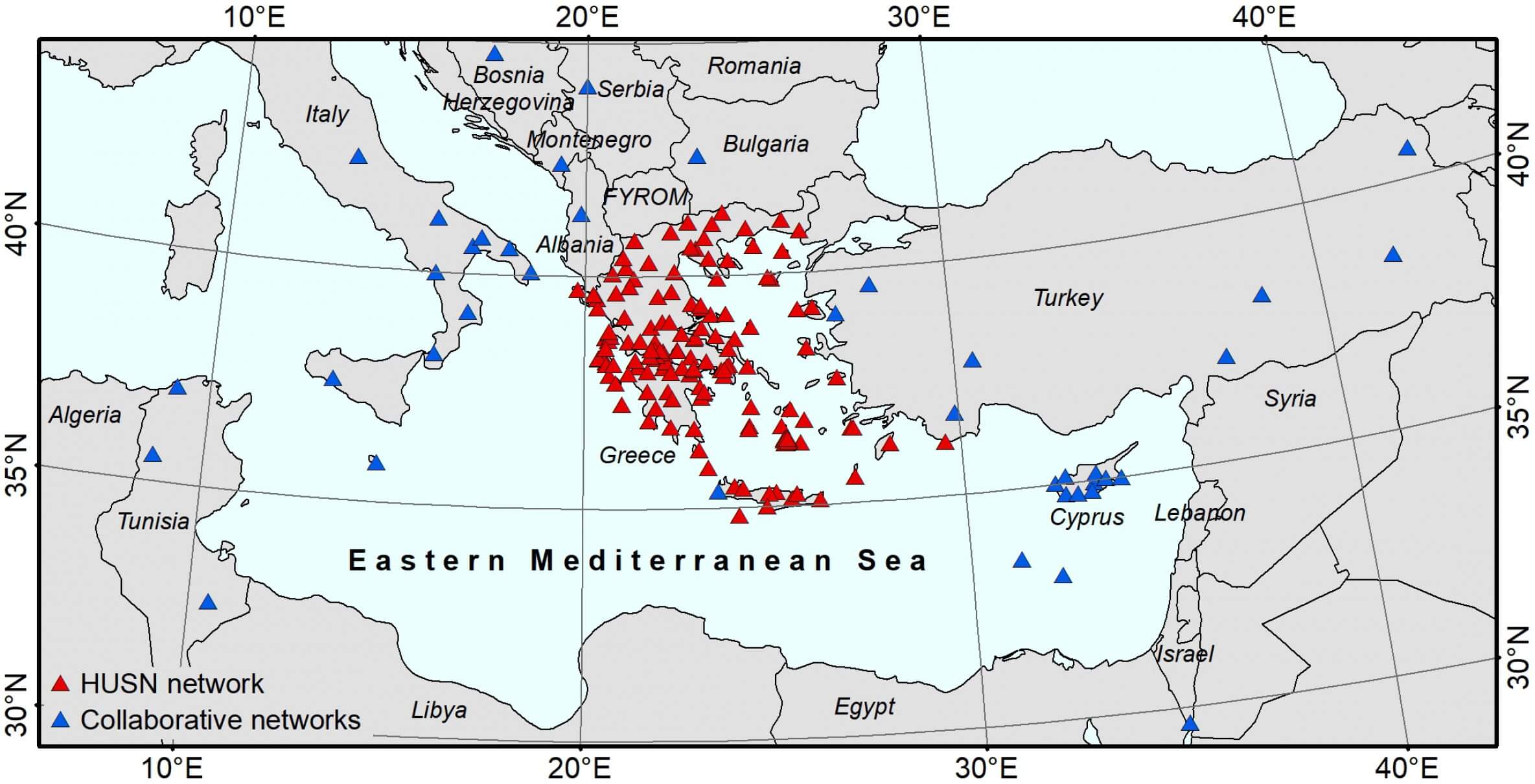
Map showing seismic stations being available online at NOA-IG.
Tide gauge Network
For the monitoring of sea level changes, the HL-NTWC is supported mainly by its own tide gauge network which has been developed since 2013 and is expanding through funding from several national and international projects. The real-time tide gauge network of NOA consists of real-time stations equipped with radar and/or pressure type sensors with very high frequency of sampling rate, which is suitable to record tsunami waves and to support tsunami operations. Station records are provided to IOC Sea Level Station Monitoring Facility and JRC and are openly accessible in real time. Eight stations were installed and operate in collaboration with JRC (Joint Research Centre) of EU at Ispra, Italy, while one station was installed in Thessaloniki by ITSAK and is linked with HL-NTWC transmitting data in real time.
In addition to its own tide gauge network, HL-NTWC receives sea level recordings from other newtworks, primarily through the IOC Sea Level Station Monitoring Facility. Selected tide gauge stations operated by the Hellenic Navy Hydrographic Service (HNHS) are accessed via ftp communication.
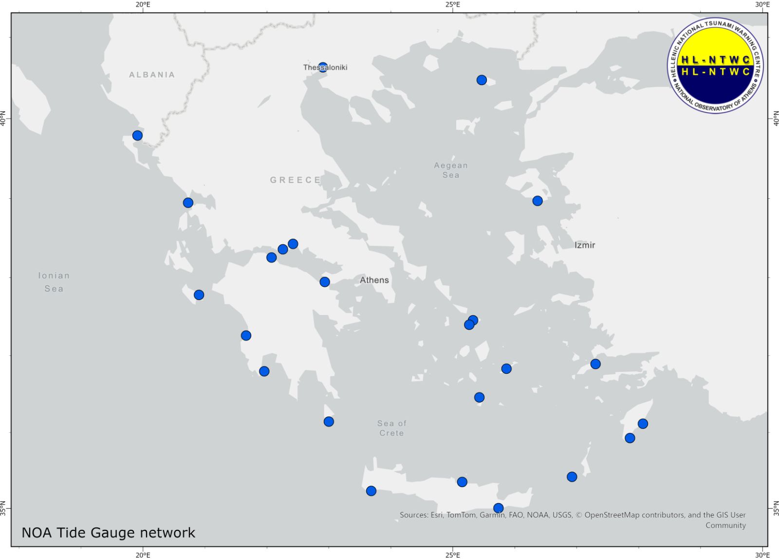
Map showing locations of NOA-IG tide gauge stations.
Strong Motion Network
The Strong Motion Network of the Institute of Geodynamics consists of about 150 stations all over the country, several of them being collocated with seismograph stations. Each station operates in either continuous or triggering mode.
The accelerometric and macroseismic networks of the Institute of Geodynamics, National Observatory of Athens are analysed in accelnet.gein.noa.gr.
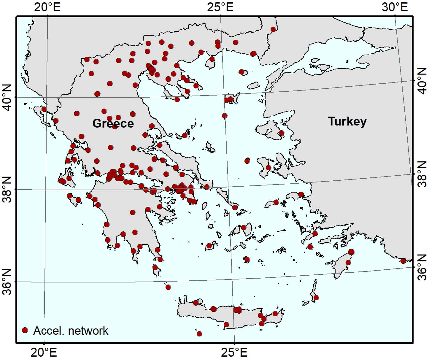
Map showing Accelerometric stations being available online at NOA-IG.
NOANet Global Navigation Satellite System (GNSS)
The National Observatory of Athens operates the NOANET, which is a continuously operating GNSS network in Greece for regional studies in seismology and geodynamics. The NOANET is a real-time, high-rate GNSS network aiming to support both Greek and International geophysical research employing GNSS to measure coseismic, postseismic, and interseismic deformation across major fault zones; plate motion and crustal deformation at plate boundaries in the eastern Mediterranean and volcano deformation.
The network currently comprises 23 stations, all of which are installed on bedrock. They are connected to the main server in Athens via Internet or leased telephone lines. All stations are equipped with dual-frequency GPS receivers. Our stations collect data every 1 s and transmit them to Athens on hourly files. 5-Hz (0.2 s) data are also collected on the ring buffer and remain available for manual download for a period of 48 hours. Data archiving is performed in two modes: a) 1-s raw data of each station are archived in hourly intervals and b) daily data for each station are archived in 30-s sampling rates.
The network server in Athens is collecting data in automatic mode and a daily file is created at mid-night by sub-sampling the hourly observations every 30-s intervals. This file is converted to RINEX format and delivered to the NOA Web Server where it is available for immediate download. In the last couple of years NOA cooperates closely with INGV for the installation of new stations in western Greece for better monitoring of deformation associated with large earthquakes and with the purpose to support tsunami operations.
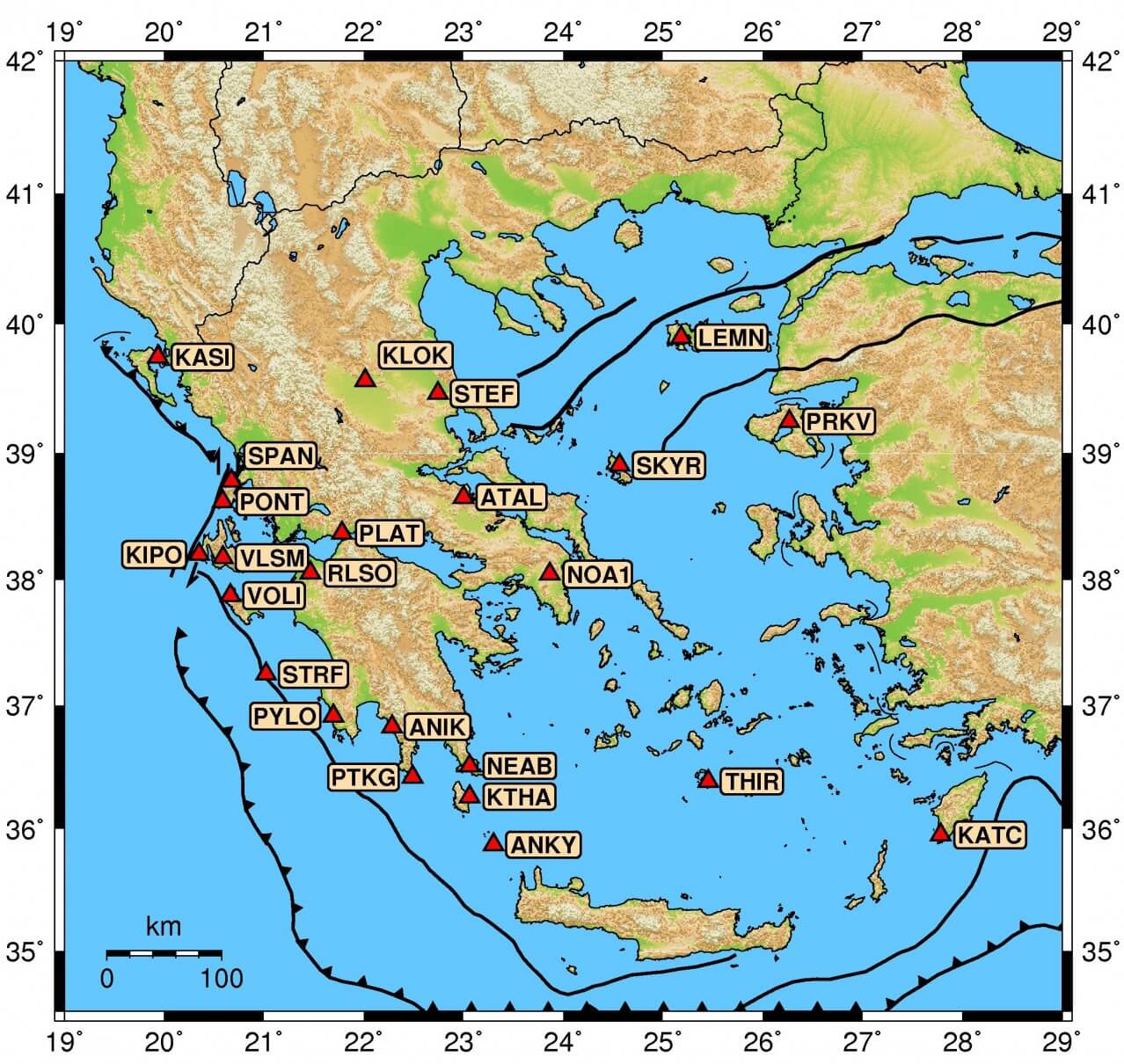
Map showing NOANET stations being available online at NOA-IG.
Software-Algorithms
The main tools that are used by the duty officers in HL-NTWC are the SeisComP3 and the Tsunami Analysis Tool (TAT). SeisComP3 is a widely distributed software package for seismological data acquisition and real-time data exchange. It is designed as a high standard fully automatic data acquisition and a near real-time data processing tool including earthquake detection and automatic location, quality control, and dissemination of event alerts.
The main software tool for tsunami monitoring and analysis used by the HL-NTWC staff is the Tsunami Analysis Tool (TAT) developed by the JRC. TAT provides a dedicated Decision Support Tool that allows the analysis of the tsunami events. It is automatically collecting earthquake events worldwide from a series of agencies (USGS, EMSC, GEOFON), including automatic and revised information about earthquakes recorded in Greece and the eastern Mediterranean, located by the earthquake monitoring system that operates at NOA-IG.
For the estimation of the tsunami arrival times, the Tsunami Travel Times (TTT) software by Geoware, kindly provided by NOAA-USA, is utilized. The tool has been incorporated within TAT, therefore it gives the ability, besides run it as a standalone tool, to use it as a part of the whole tsunami monitoring process. The calculations are based on the available bathymetric files. For regional calculations, GEBCO’s gridded bathymetric data sets with 1 arc-minute interval grid are used.
TAT is also directly linked to scenario databases that consist of simulation models developed at JRC, using the SWAN code. In this way, the HL-NTWC duty officers can estimate the wave heights near the coast, as well as the wave arrival times in an alternative way. TAT is mainly and closely linked with the ICG/NEAMTWS tsunami Decision Matrix for the Mediterranean Sea.
Besides the SeisComP3 suite, which is the basic tool for earthquake monitoring at NOA-IG/HL-NTWC, the software package Early-est, developed by INGV (Rome), that includes global monitoring using also IRIS and GFZ on line available seismic stations, is also used for real-time earthquake monitoring and for tsunami early warning based on specific discriminants for earthquake tsunami potential.